Rothrock State Forest, PA
Description
Book a Campsite at Rothrock State Forest, PA
** Arrival dates earlier than the online-reservation-window may also be available at the campground.
*** Some sites may be available only from the campground on a first-come-first-served basis.
Description
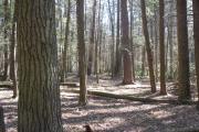
The Rothrock State Forest is located in central Pennsylvania within the Ridge and Valley province. It consists of approximately 97,000 acres located in Huntingdon, Centre, and Mifflin Counties. Over 80 percent of the forest is in one unbroken tract containing 80,449 acres, the northern boundary of which follows Tussey Mountain from the Frankstown Gap at Water Street across the northern part of Huntingdon County and on to the eastern edge of the forest in Centre County - a total distance of approximately 27 miles. The southern boundary of this same tract follows Stone Mountain from Martin’s Gap northeastward to U.S. 322 in Mifflin County. At its widest point this tract is approximately nine miles wide. The rest of the Rothrock State Forest is composed of several scattered tracts; the largest of these, which contains 11,333 acres, is in southwestern Huntingdon County in the drainage of Great Trough Creek. Four remaining tracts are: Jack’s Mountain Tract, which is located on the east slope of Jack’s Mountain in southern Huntingdon County and contains 578-acres; Lucy Furnace Tract located in Mifflin County about one mile north of Mount Union totaling 2,295-acres; the Locke Valley Tract, located just north of Shade Gap in southern Huntingdon county, consisting of 1,622-acres; and Dry Hollow, 1,271-acres in Warriors Mark Township, Huntingdon County, and Ferguson and Halfmoon Townships, Centre County.
The area in which the Rothrock State Forest is located has an interesting historical background. The well-known Jack's Mountain, through which the Juniata River flows, was named in honor of Captain Jack Armstrong, a famous Native American fighter. The name of Chief Logan, celebrated Native American Chief and scout during Revolutionary War days, is almost a byword in this region. A part of the Rothrock was originally the Logan State Forest. The "Indian Steps" on State Forest land, legend has it, were built by the Lenape to quickly cross Tussey Mountain between Spruce Creek and Stone Creek.
Most of the land that makes up the Rothrock State Forest was purchased from the Logan Iron and Steel Company and from various local lumber companies. Evidence of the early iron and lumber industries can still be found throughout the forest in the form of charcoal hearths and tram road grades.
More information on the Rothrock State Forest can be found on our website or on our Facebook page.
Geography:
The Forest District is located in the Ridge and Valley area of the Appalachians. Elevations vary from 500 to 2400 feet. There are many small mountain streams and several rivers in the area.
The Rothrock State Forest contains many unique natural features. Six areas of land with special significance have been designated as State Forest Natural Areas totaling 2,701 acres. Bear Meadows contains a fen wetland, a national natural landmark and Alan Seeger and Detweiler Run support old-growth hemlock and whitepine. An additional 6,589 acres are classified as Wild Areas, which are the Thickhead Mountain and Trough Creek Wild Areas.
Recreation:
Hiking, equestrian, and mountain biking enthusiasts have abundant opportunities on the many trails that traverse the rugged mountain terrain in the Rothrock State Forest. Hunting for deer, turkey, bear, and a variety of small game are popular activities enjoyed by visitors. Some of the mountain streams are annually stocked with trout, while the Juniata River, which borders the forest, provides good fishing for bass and other warm water fish. Many of the District’s mountain streams hold populations of wild trout. Rothrock State Forest is also host to four (4) State Parks; Whipple Dam, Greenwood Furnace, Penn Roosevelt, and Trough Creek.
Sightseeing is a popular activity and the many miles of public use roads provide opportunities to view wildlife and brilliant fall foliage and there are a number of scenic vistas that overlook the surrounding countryside.
For maps of the area visit the Rothrock State Forest map page.
Facilities:
Rothrock State Forest is managed primarily for dispersed recreation and facilities are limited. There are picnicking facilities available including at the Alan Seeger and Pine Hill State Forest Picnic Areas that provide pavilions, tables, grills, and latrines. The forest also offers eight designated, primitive roadside campsites with picnic table and fire rings.
Nearby Attractions:
Check out the local visitor bureau’s websites for local attractions, at: https://www.raystown.org/ https://happyvalley.com/
Reservations can be made for today and can be made up to 11 Month(s) in advance.
- Bird Watching
- Camping, Backcountry
- Camping, Equestrian
- Camping, Equestrian Group
- Camping, Primitive
- Canoeing
- Fire Rings
- Fishing
- Fishing - River/Stream
- Hiking Difficult
- Hiking Moderate
- Hiking Trail
- Historic Sites
- Historical Areas/Struct.
- Horseback Riding
- Hunting
- Jogging/Running
- Kayaking
- Mountain/Trail Bicycling
- Nature Study
- Office/Ranger Station
- Photography
- Picnic Tables
- Rock Climbing
- Scenic Driving Routes
- Trails Hiking/Walking, Easy
- Trails, Difficult Hiking
- Trails, Moderate Hiking
- Trails, Mountain Bike
- Viewing Platform/Overlk
- Walking
- Water Access, River/Stream
- Wildflower Viewing
- Wildlife Viewing
- river/stream
- trails - equestrian
40.49147, -78.03653
40°29'29"N, 78°2'12"W
The District Office is located at 181 Rothrock Lane, in Huntingdon, PA. We are at the intersection of state routes 26 and 22.
Nearby Parks


 Flickr