Michaux State Forest, PA
Description
Book a Campsite at Michaux State Forest, PA
** Arrival dates earlier than the online-reservation-window may also be available at the campground.
*** Some sites may be available only from the campground on a first-come-first-served basis.
Description
Michaux State Forest encompasses more than 85,500 acres in the South Mountain area of Adams, Cumberland, and Franklin County.
Considered Pennsylvania’s “cradle of forestry”, Michaux is the site of the first forestry school, Mont Alto. The forest is named for the French botanist, Andre Michaux, who discovered and named many plants during the 18th century.
For more information visit the Michaux State Forest website and Facebook page.
Geography:
The Michaux Forest District spans five distinct ecoregions ranging from the Great Valley along the northwestern border of the district and across the South Mountain, Gettysburg Newark Lowland, Piedmont Lowland, and Piedmont. The state forest lands are mostly located on the meta volcanic and quartzite rocks of South Mountain at the northern terminus of the scenic Blue Ridge Mountains. The largely contiguous block of state forest provides excellent watershed protection within the Potomoc River Basin and the Susquehanna/Chesapeake Basin.
The Michaux State Forest is dominated by dry oak-heath forest types and contains unique ridgetop barren ecosystems, vernal pools, and talus slopes. There are four state forest natural areas that are recognized for their unique features such as the Meeting of the Pines Natural Area which is the only location where all fives species of native pines are found growing together.
Recreation:
Many recreational pursuits can be enjoyed on the Michaux State Forest such as hiking, biking, horseback riding, camping, hunting, fishing, boating, sightseeing, wildlife viewing, rock climbing and ATV/snowmobile riding. There are also many historical sites.
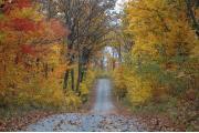
There are over 100 miles of trails, including 36 miles of the Appalachian National Scenic Trail. Visitors will be greeted by many scenic highlights in the Michaux State Forest, including 7 vistas, mountain laurel and rhododendron blooms, and fall foliage. Over 130 miles of gravel roads offer opportunities for appreciation of Michaux’s natural beauty and act as gateways to many other recreational activities.
Camping in the Michaux State Forest is a great way to get away from it all and spend a night in the great outdoors. These designated, roadside campsites are identified by signpost and campsite name. Most are remote, designated sites with no amenities although some may include a fire ring and picnic table. Some sites may require a short walk-in from the road while others can be immediately accessed by vehicle.
For trail maps visit the Michaux State Forest Map webpage.
Facilities:
The Michaux State Forest has several notable amenities that provide for unique and memorable experiences.
The Michaux Target Shooting Range is located on Birch Run Road in Franklin Township, Adams County, and offers a 70 yard rifle range as well as a 25 yard multi-distance pistol range. A valid DCNR range permit is required. Permits are available for purchase at the Michaux State Forest District office during weekdays.
The Old Forge Picnic Area, located 4.5 miles south of the Village of South Mountain features two pavilions, picnic tables, grills, restrooms, playground equipment, and an athletic field.
Nearby Attractions:
Caledonia State Park; Mont Alto State Park; Kings Gap Environmental Education Center; Pine Grove Furnace State Park; Gettysburg National Military Park; Gettysburg National Military Park
Roadside
Tue Nov 05 2024 - Sat Oct 04 2025Reservations can be made for today and can be made up to 11 Month(s) in advance.
Roadside Hike-in
Tue Nov 05 2024 - Sat Oct 04 2025Reservations can be made for today and can be made up to 11 Month(s) in advance.
State Forest Rustic
Tue Nov 05 2024 - Sat Oct 04 2025Reservations can be made for today and can be made up to 11 Month(s) in advance.
Season Schedule
- ATV Riding
- Archeological Sites
- Archery
- Bird Watching
- Canoeing
- Cultural Activities
- Fishing - River/Stream
- Geological Formations
- Golfing
- Hiking
- Hiking Difficult
- Hiking Moderate
- Hiking Trail
- Historic Sites
- Horseback Riding
- Hunting
- Kayaking
- Lodging, Group Facilities
- Mountain/Trail Bicycling
- Photography
- Picnicing
- Rock Climbing
- Shooting Range
- Sightseeing
- Snowmobiling
- Trails Hiking/Walking, Easy
- Trails, Bicycle
- Trails, Difficult Hiking
- Trails, Moderate Hiking
- Trails, Mountain Bike
- Viewing Platform/Overlk
- Water Access, River/Stream
- Wildlife Viewing
- river/stream
- trails - equestrian
39.90475, -77.47053
39°54'17"N, 77°28'14"W
The District Office is located on Route 30, 12 miles from Gettysburg and 10 from Chambersburg.
From 1-81 North, take Route 30 at exit 16. Travel 8.5 miles on Route 30.
From I-81 South, take the Scotland Exit and travel 997 South to Route 30. Turn left toward Gettysburg. Travel 2.5 miles on Route 30.
From Route 233 South, turn right onto Route 30 for .4 miles. From Route 233 North, turn left onto Route 30 for .4 miles.
Nearby Parks


 Flickr